
KEPLER'S OVERLOOK
- Mar 15, 2021
- 2 min read
Updated: May 14, 2021
Kepler's Overlook via the Tuscarora Trail is a beautiful day hike or overnight backpacking trail in GWNF.

DETAILS
Length: 7 mile out-and-back
Elevation Gain: 1,250 feet
Difficulty: Moderate
Location: 8.9789326,-78.5679648 (Click for directions)
Nearest Town: Tom's Brook, VA
Kepler's Overlook is located in George Washington National Forest and is a fantastic, moderately difficult day hike that offers two overlooks and multiple stream crossings.
GETTING THERE
To start the hike to Kepler's Overlook, park at the end of Van Buren Road in Mauretown, Virginia. There is no marked parking area; you'll know you're there when you see two large camp spots on either side of the road directly before a gate. We parked on the right side of the road and had no issues getting in or out with our car.
CEDAR CREEK FOREST ROAD

The first 0.5 miles of the trail follows the yellow-blazed Cedar Creek forestry road. This section is wide and while it does gain elevation, the incline is very minimal. There are two camp spots on this first stretch - both of them would make a great backpacking spot for anyone who is a beginner or not wanting to hike far.
TUSCARORA TRAIL

At the 0.6 mile mark, the Cedar Creek forestry road intersects with the Tuscarora Trail. Turn left and begin following the blue-blazed trail. In a few hundred yards, the trail crosses a small (mostly dry) stream, followed by a closed gate. Continue around the gate, following the blue blazes.
CEDAR CREEK CROSSING

The Tuscarora Trail crosses Cedar Creek around the 0.8-mile mark. The water was low and there was a bridge of rocks for us to cross the creek without getting our feet wet. If it did rain, however, it would be very difficult to cross the creek without getting your hiking boots submerged.
After crossing Cedar Creek, there is a huge, flat campsite to the left that borders the stream. There is a large established fire ring and plenty of places to set up a tent or hammock. Continue past the campsite, following the blue blazes.

A few hundred yards further the trail crosses another small stream. There is a sign indicating that a log bridge was once there, but has been since taken out. Cross the small stream, then begin the ascent to Tea Mountain.
SPRING
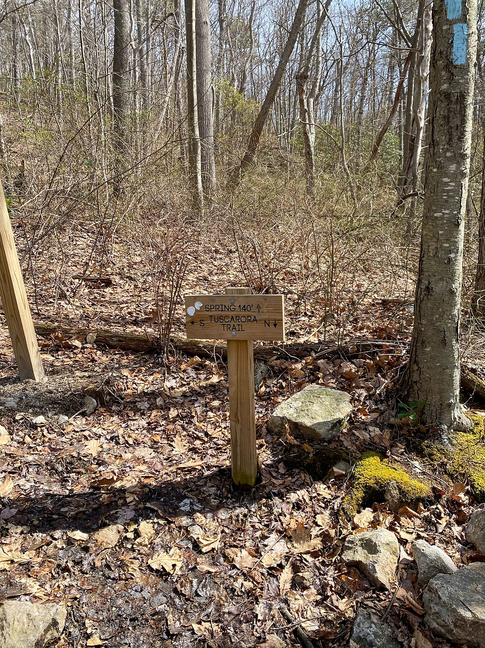
Around the 2.1-mile mark, the wide trail turns left at a small wooden sign that marks a spring, as well as the North/South direction of the Tuscarora Trail. While there is a small stream 140' straight ahead, don't go to it. Continue following the Tuscarora Trail to the left and another fresh, mountain spring is literally in the middle of the trail!
The Potomac Appalachian Tuscarora Club (PATC) that maintains this trail put in a PVC pipe at the spring in 2018. It makes it much easier to fill up a water bottle or water bag. This is the last water source before the summit, so backpackers should fill up here before continuing on.

After passing the spring, the incline gets much steeper and the trail becomes narrow and very rocky. Follow the blue-blazed trail up a series of switchbacks.

Comments